Journal Description
Water
Water
is a peer-reviewed, open access journal on water science and technology, including the ecology and management of water resources, and is published semimonthly online by MDPI. Water collaborates with the International Conference on Flood Management (ICFM) and Stockholm International Water Institute (SIWI). In addition, the American Institute of Hydrology (AIH), The Polish Limnological Society (PLS) and Japanese Society of Physical Hydrology (JSPH) are affiliated with Water and their members receive a discount on the article processing charges.
- Open Access— free for readers, with article processing charges (APC) paid by authors or their institutions.
- High Visibility: indexed within Scopus, SCIE (Web of Science), Ei Compendex, GEOBASE, GeoRef, PubAg, AGRIS, CAPlus / SciFinder, Inspec, and other databases.
- Journal Rank: JCR - Q2 (Water Resources) / CiteScore - Q1 (Water Science and Technology)
- Rapid Publication: manuscripts are peer-reviewed and a first decision is provided to authors approximately 16.5 days after submission; acceptance to publication is undertaken in 2.9 days (median values for papers published in this journal in the second half of 2023).
- Recognition of Reviewers: reviewers who provide timely, thorough peer-review reports receive vouchers entitling them to a discount on the APC of their next publication in any MDPI journal, in appreciation of the work done.
- Companion journals for Water include: GeoHazards and Hydrobiology.
Impact Factor:
3.4 (2022);
5-Year Impact Factor:
3.5 (2022)
Latest Articles
Short-Term Observations of Rainfall Chemistry Composition in Bellsund (SW Spitsbergen, Svalbard)
Water 2024, 16(2), 299; https://doi.org/10.3390/w16020299 - 15 Jan 2024
Abstract
Global warming results in increasingly widespread wildfires, mostly in Siberia, but also in North America and Europe, which are responsible for the uncontrollable emission of pollutants, also to the High Arctic region. This study examines 11 samples of rainfall collected in August in
[...] Read more.
Global warming results in increasingly widespread wildfires, mostly in Siberia, but also in North America and Europe, which are responsible for the uncontrollable emission of pollutants, also to the High Arctic region. This study examines 11 samples of rainfall collected in August in a coastal area of southern Bellsund (Svalbard, Norway). It covers detailed analysis of major ions (i.e., Cl−, NO3−, and SO42−) and elements (i.e., Cu, Fe, Mn, Pb, and Zn) to Hybrid Single-Particle Langrarian Integrated Trajectory( HYSPLIT) backward air mass trajectories. The research of wildfires, volcanic activities, and dust storms in the Northern Hemisphere has permitted the assessment of their relations to the fluctuations and origins of elements. We distinguished at least 2 days (27 and 28 August) with evident influence of volcanic activity in the Aleutian and Kuril–Kamchatka trenches. Volcanic activity was also observed in the case of the Siberian wildfires, as confirmed by air mass trajectories. Based on the presence of non-sea K (nsK), non-sea sulphates (nss), and Ca (the soil factor of burned areas), the continuous influence of wildfires on rainfall chemistry was also found. Moreover, dust storms in Eurasia were mainly responsible for the transport of Zn, Pb, and Cd to Svalbard. Global warming may lead to the increased deposition of mixed-origin pollutants in the summer season in the Arctic.
Full article
(This article belongs to the Special Issue Water Quality Studies: Assessing the Presence of Nutrients and Pollutants)
Open AccessArticle
Geochemical Characteristics and Controlling Factors of Groundwater Chemical Composition in the Zihe River Source Area, Shandong, China
Water 2024, 16(2), 298; https://doi.org/10.3390/w16020298 - 15 Jan 2024
Abstract
The geochemical characterization and evolution of shallow groundwater in the Zihe River source area is a key issue that needs to be addressed. In this study, a combination of traditional geochemical techniques and geochemical modeling was used to explain the geochemical processes and
[...] Read more.
The geochemical characterization and evolution of shallow groundwater in the Zihe River source area is a key issue that needs to be addressed. In this study, a combination of traditional geochemical techniques and geochemical modeling was used to explain the geochemical processes and major ion sources in the chemical evolution of shallow groundwater in the Zihe River source area, Northeast China. Fifty-seven water samples were collected in June 2020 for chemical analysis, and the results showed that the main groundwater chemistry types in the three major aquifers are HCO3·SO4-Ca·Mg-type pore water from loose quaternary rocks, HCO3·SO4-Ca·Mg-type karstic fissure water from carbonate rocks, and HCO3·SO4-Ca-type weathered fissure water from massive rocks. Water–rock interactions in alkaline environments were the main causes of changes in groundwater chemistry. Rock weathering dominated the geochemical evolution of each aquifer. The analysis of ion concentration ratios and modeling revealed that the aquifer’s chemical components are mainly derived from the dissolution of dolomite and calcite and partly from the infiltration of pollutants containing
(This article belongs to the Special Issue Development and Utilization of Regional Geothermal Water Resources under the Carbon Neutral Situation)
►▼
Show Figures
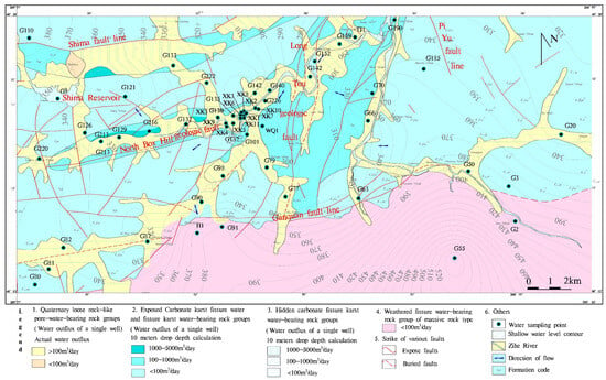
Figure 1
Open AccessArticle
Enhancing Riverbank Protection along the Jamuna River, Bangladesh: Review of Previous Countermeasures and Morphological Assessment through Groyne-Based Solutions Using Numerical Modeling
by
and
Water 2024, 16(2), 297; https://doi.org/10.3390/w16020297 - 15 Jan 2024
Abstract
This study investigated riverbank protection strategies along the dynamic Jamuna River in Bangladesh, a braided river prone to erosion and sedimentation. It reviews past countermeasures and emphasizes the effectiveness of groyne-type structures in redirecting flow and preventing erosion. Notably, the left bank exhibited
[...] Read more.
This study investigated riverbank protection strategies along the dynamic Jamuna River in Bangladesh, a braided river prone to erosion and sedimentation. It reviews past countermeasures and emphasizes the effectiveness of groyne-type structures in redirecting flow and preventing erosion. Notably, the left bank exhibited greater stability than the right bank, emphasizing the need for effective groyne installations. A systematic methodology utilizing numerical modeling using International River Interface Cooperation (iRIC Nays2DH) ensured accuracy in assessing morphological impacts. This research presents novel countermeasures incorporating groyne installations along the right bank of the Jamuna River. Simulations are undertaken to assess the effectiveness of these measures under a range of flood scenarios, identifying a zone highly prone to erosion that exhibits the utmost vulnerability. The simulation scenarios comprised a base condition without groynes, two series of groynes separately placed in two selected zones, and a combined approach for both areas. Analysis of the four simulation cases, each encompassing three flood conditions, revealed that implementing two ‘I’-shaped perpendicular groynes in series within the erosion-prone area effectively diverted oblique flow. This approach proved optimal, mitigating erosion risk by redirecting flow and shaping sandbars along the Jamuna River’s riverbank. This study enhances Jamuna River protection, emphasizing groyne-type structures’ importance and promoting a holistic understanding of morphological dynamics for future river management and effective countermeasures.
Full article
(This article belongs to the Special Issue Challenges to Interdisciplinary Application of Hydrodynamic Models)
►▼
Show Figures
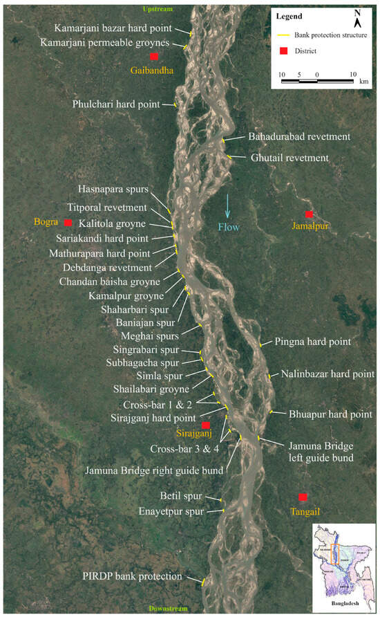
Figure 1
Open AccessArticle
The Effect of Different Swell and Wind-Sea Proportions on the Transformation of Bimodal Spectral Waves over Slopes
Water 2024, 16(2), 296; https://doi.org/10.3390/w16020296 - 15 Jan 2024
Abstract
In the laboratory experiment, 1:25 scaled models are constructed to investigate the effect of different swell and wind-sea proportions on the wave transformation. The source of the wave spectrum is related to the wave conditions in the Gulf of Guinea. Swell from the
[...] Read more.
In the laboratory experiment, 1:25 scaled models are constructed to investigate the effect of different swell and wind-sea proportions on the wave transformation. The source of the wave spectrum is related to the wave conditions in the Gulf of Guinea. Swell from the westerlies and local wind-sea forms the bimodal spectral waves in the region. To better understand the transformation of bimodal spectral waves, a series of wave conditions are measured by the wave gauges in a wave flume. Based on the wave spectrum at the Bight of Benin, the wave transformation along the slopes and variations of different swell proportions are analyzed. The result of the wave height variations shows that the slope and swell proportion play a significant role in the maximum wave height, and the wave height has an upward trend with a large swell proportion. The analysis of wave nonlinearity is conducted, showing that the large swell proportion in the wave spectrum leads to a more significant nonlinearity before wave breaking. Combining the variations of wave height and wave nonlinearity, the influence of bimodal spectral waves on nearshore wave prediction, shoreline change, marine operations, and structure design is discussed.
Full article
(This article belongs to the Section Oceans and Coastal Zones)
►▼
Show Figures
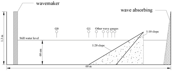
Figure 1
Open AccessArticle
Controlling Phosphorus Transport in Poyang Lake Basin under the Constraints of Climate Change and Crop Yield Increase
Water 2024, 16(2), 295; https://doi.org/10.3390/w16020295 - 15 Jan 2024
Abstract
►▼
Show Figures
Phosphorus, as a key nutrient, plays an essential role in both algal growth in surface waters and crop development on land. Its presence in inorganic fertilizers is crucial for maximizing crop yields. However, an excessive accumulation of phosphorus in soils can lead to
[...] Read more.
Phosphorus, as a key nutrient, plays an essential role in both algal growth in surface waters and crop development on land. Its presence in inorganic fertilizers is crucial for maximizing crop yields. However, an excessive accumulation of phosphorus in soils can lead to its loss and exacerbate eutrophication in water bodies. This study highlights the complex interplay among phosphorus management, agricultural productivity, and environmental health, particularly in the context of climate change’s influence on sediment transport and water pollution. We focus on the Poyang Lake Basin (PLB) and use a sophisticated process-based phosphorus model to forecast phosphorus load trends from 2020 to 2049. Our predictions indicate a significant increase in the total phosphorus load of the PLB due to the impact of climate change. To address these challenges, we explore a novel strategy combining organic and inorganic phosphorus fertilizers. This approach aims to improve crop yields while reducing non-point source phosphorus pollution through adjusted anthropogenic inputs. Our findings reveal that a synergistic application of these fertilizers, coupled with a controlled use of inorganic phosphate, can reduce its usage by more than 2.5% annually. This method not only contributes to a 2.2% average annual increase in livestock and poultry production but also promotes a 0.6% yearly growth in grain output. Consequently, it effectively diminishes non-point source phosphorus pollution, offering a sustainable solution to the dual challenge of enhancing agricultural productivity and protecting environmental health.
Full article
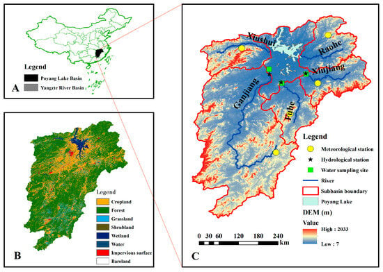
Figure 1
Open AccessArticle
Adsorption and Kinetics Modelling for Chromium (Cr6+) Uptake from Contaminated Water by Quaternized Date Palm Waste
by
, , , , and
Water 2024, 16(2), 294; https://doi.org/10.3390/w16020294 - 15 Jan 2024
Abstract
The pervasive challenge of heavy metal pollution in water necessitates urgent interventions to mitigate chromium contamination. It poses significant threats to human health, aquatic ecosystems, and the environment. This research delves into the potential of date palm waste as a precursor of adsorbent
[...] Read more.
The pervasive challenge of heavy metal pollution in water necessitates urgent interventions to mitigate chromium contamination. It poses significant threats to human health, aquatic ecosystems, and the environment. This research delves into the potential of date palm waste as a precursor of adsorbent for extraction of chromium from contaminated water, underscoring its potential in heavy metal remediation. Date palm waste, traditionally regarded as agricultural waste, underwent modification employing N-(3-chloro-2-hydroxypropyl) trimethylammonium chloride resulting in quaternized date palm waste (QDPW) as a prospective adsorbent for chromium extraction. The characterization techniques, including FTIR, SEM/EDX, BET, XRD, TGA/DTA, and element analysis, were employed to examine the structural and surface properties of both DPW and QDPW fibers. Optimal chromium uptake was achieved at a solution pH 6.5 over two hours, with a peak removal efficiency of 88% and an adsorption capacity of 22.26 mg/g. The equilibrium isotherms studies are consistent with Langmuir, Redlich-Peterson, and Sips isotherms, presenting a coefficient of determination (R2) of 0.989, 0.981, and 0.983, respectively. Moreover, the pseudo-second-order model was mostly aligned with the kinetics data with R2 value of 0.999. These findings showed that the quaternized date palm waste can be considered a good option to recycle the date palm waste and reduce the environmental threats in aqueous solution.
Full article
(This article belongs to the Section Wastewater Treatment and Reuse)
►▼
Show Figures
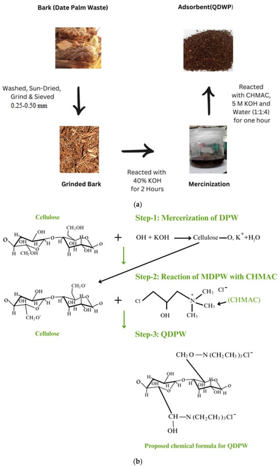
Figure 1
Open AccessArticle
Evaluation of Field Applicability of Sewage Treated with an Electrochemical Floatation System Coupled with a Separation Membrane Process
Water 2024, 16(2), 293; https://doi.org/10.3390/w16020293 - 15 Jan 2024
Abstract
An electrochemical floatation system (EFS)-based sewage-treatment process that applied a dimensionally stable anode (DSA) was developed to secure treated sewage water from sewage-treatment plants for reuse. The DSA was fabricated at a temperature of 673–923 K by dispersing a low quantity of activated
[...] Read more.
An electrochemical floatation system (EFS)-based sewage-treatment process that applied a dimensionally stable anode (DSA) was developed to secure treated sewage water from sewage-treatment plants for reuse. The DSA was fabricated at a temperature of 673–923 K by dispersing a low quantity of activated carbon on a titanium plate coated with mixed metal oxides (Pt, Re, Pd, Re, and Ir) to a thickness of 5 μm. The average size of the bubbles generated through the DSA of the EFS was 20–40 μm, thus confirming microbubble generation. An efficiency assessment of a titanium-based DSA confirmed metal oxide activity through the removal of Escherichia coli (100%) and total organic carbon (TOC; 48.83%) at a reaction time shorter than 10 min and a low current density (19.6 A/m2). During the long-term operation of the EFS with the separation membrane process, the average removal efficiency was 94.7%, 90.0%, 96.1%, 90.9%, and 98.0% for suspended solids, biochemical oxygen demand, TOC, total nitrogen, and total phosphorous, respectively. Coliforms were not detected. Overall, our EFS coupled with the separation membrane process produced high-quality recycled water that could be used for various purposes according to the water-quality standards for different applications.
Full article
(This article belongs to the Section Wastewater Treatment and Reuse)
►▼
Show Figures
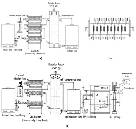
Figure 1
Open AccessArticle
Effects of Extreme-Ambient Temperatures in Silver Barb (Barbonymus gonionotus): Metabolic, Hemato-Biochemical Responses, Enzymatic Activity and Gill Histomorphology
by
, , , , , , , and
Water 2024, 16(2), 292; https://doi.org/10.3390/w16020292 - 15 Jan 2024
Abstract
A global interest in Silver Barb (Barbonymus gonionotus) cultivation has arisen because of a combination of declining wild stock and a steady increase in demand and market value. The purpose of the current investigation was to evaluate the impact of extreme
[...] Read more.
A global interest in Silver Barb (Barbonymus gonionotus) cultivation has arisen because of a combination of declining wild stock and a steady increase in demand and market value. The purpose of the current investigation was to evaluate the impact of extreme water temperature changes on growth, hemato-biochemical responses, pepsin enzyme activity and gill histomorphology of B. gonionotus. Four distinct temperatures (22, 26, 30 and 34 °C) were applied in the laboratory (22, 26, 30 and 34 °C) in triplicate glass aquariums (150 L each). At 30 and 22 °C, respectively, the highest and the lowest length and weight gain, specific, daily and relative growth rates were noted. At 30 °C the lowest FCR was recorded (1.42 ± 0.04). The values related to hematology and biochemistry were found to be within normal ranges; nevertheless, there was a notable variation in the parameters when the temperature changed. Hematological results revealed that RBC, HB, PLT, HCT and PMV levels were significantly higher in groups 30 °C with respect to others. It was evident that cold and heat shock stress was present due to the decline in hematocrit levels and rise in WBC values. Regarding the biochemical responses, the level of triglycerides, cholesterol, AP, Ca+, HDL, and HDL/LDL ratio increased significantly higher at 30 °C. Glucose, total protein, albumin, Na+, K+, Cl−1, AST, bilirubin, uric acid, and LDL levels were significantly higher at 22 °C compared to other temperatures. There was a higher pepsin activity between 26 and 30 °C while the digestive somatic index (IDS) was disproportionate. Histological examination demonstrated the well-shaped gill tissues at 26 and 30 °C compared to distinctive pathology in other temperature treatments. As an end note, the results of the experiment indicated that B. gonionotus should be cultured at 26–30 °C to maximize the overall productivity and the health condition of this economically important fish species.
Full article
(This article belongs to the Special Issue Impact of Climate Changes on Marine Ecology and Fishes)
►▼
Show Figures
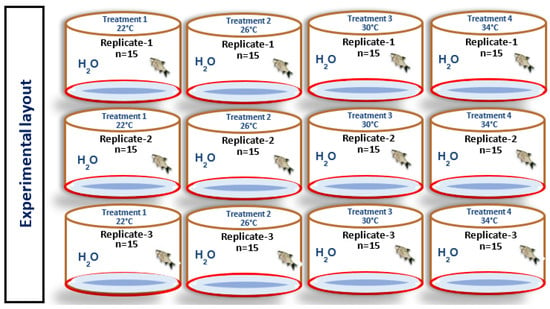
Figure 1
Open AccessArticle
Analysis of Influencing Factors of Heavy Metals and Non-Point Source Pollution in Typical Areas of Tethys Himalayan Tectonic Domain
Water 2024, 16(2), 291; https://doi.org/10.3390/w16020291 - 15 Jan 2024
Abstract
Due to their potential toxicity and non-degradability, heavy metals pose water and soil quality and safety challenges, impacting crop growth and the ecological environment. The contamination of heavy metals (HMs) and non-point source pollution from agriculture and pastoral presents significant ecological and environmental
[...] Read more.
Due to their potential toxicity and non-degradability, heavy metals pose water and soil quality and safety challenges, impacting crop growth and the ecological environment. The contamination of heavy metals (HMs) and non-point source pollution from agriculture and pastoral presents significant ecological and environmental challenges, necessitating prioritized prevention and mitigation. In this study, 44 water samples and 55 soil samples from Gangba County, a typical agricultural and pastoral area in the Tethys Himalaya tectonic domain, served as research objects. We employed various methods, including the inverse distance weighting, ecological risk assessment model, redundancy analysis, and geographical detector modeling, to investigate the spatial distribution and pollution attributes of arsenic (As), chromium (Cr), cadmium (Cd), lead (Pb), nickel (Ni), nitrogen (N), phosphorus (P), and potassium (K). Our analysis considered the impact of soil physicochemical properties on heavy metals (HMs), elucidating factors influencing their spatial distribution. Results indicated that 65.46% of soil As in the study area exceeded the screening value, while the concentrations of the eight selected elements in water remained below the standard limit. Simultaneously, the study area exhibited low overall ecological risk and minimal HM pollution. Furthermore, As and Pb were primarily linked to human activities and the environment, while Cd, Cr, and Ni were predominantly associated with natural processes. Additionally, factors, such as per capita net income, mean annual temperature, mean annual precipitation, geomorphic type, organic matter, geology type, and soil texture (sand, silt, and clay) constituted primary controlling factors influencing the spatial distribution of HMs in soil. Therefore, for effective prevention and control of HMs and non-point source pollution in agriculture and pastoral, arsenic should be the primary monitoring target, with careful consideration given to the application rates of fertilizers containing N, P, and K to facilitate sustainable development of the ecological environment.
Full article
(This article belongs to the Special Issue Soil and Water Management: Practices to Mitigate Nutrient Losses in Agricultural Watersheds)
►▼
Show Figures

Figure 1
Open AccessArticle
Investigation of the Recent Ice Characteristics in the Bohai Sea in the Winters of 2005–2022 Using Multi-Source Data
by
, , , , , , , and
Water 2024, 16(2), 290; https://doi.org/10.3390/w16020290 - 15 Jan 2024
Abstract
The safety of winter activities in the Bohai Sea requires more detailed information on ice characteristics and a more refined ice zone division. In the present study, 1/12°-resolution sea ice characteristic data were obtained based on the NEMO-LIM2 ice–ocean coupling model that assimilated
[...] Read more.
The safety of winter activities in the Bohai Sea requires more detailed information on ice characteristics and a more refined ice zone division. In the present study, 1/12°-resolution sea ice characteristic data were obtained based on the NEMO-LIM2 ice–ocean coupling model that assimilated MODIS satellite sea ice observations from the years of 2005 to 2022 to acquire new sea ice hindcasting data. On this basis, the ice period, ice thickness, ice concentration, ice temperature, ice salinity, and design ice thickness for different return periods in the 1/4°-resolution refined zoning were analyzed, which were then compared with the sea ice characteristics in the previous 21-ice-zone standard. The distribution of ice temperature and ice salinity was closely related to the distribution of ice thickness. The results of ice period, ice thickness, and ice concentration, as well as design ice thickness for different return periods, and the comparison with the previous 21-ice-zone standards, showed that the ice condition on the west coast of the Bohai Sea has significantly reduced.
Full article
(This article belongs to the Special Issue Cold Regions Ice/Snow Actions in Hydrology, Ecology and Engineering)
►▼
Show Figures
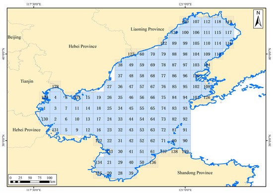
Figure 1
Open AccessArticle
Comparative Analysis of Convolutional Neural Network-Long Short-Term Memory, Sparrow Search Algorithm-Backpropagation Neural Network, and Particle Swarm Optimization-Extreme Learning Machine Models for the Water Discharge of the Buzău River, Romania
by
and
Water 2024, 16(2), 289; https://doi.org/10.3390/w16020289 - 15 Jan 2024
Abstract
Modeling and forecasting the river flow is essential for the management of water resources. In this study, we conduct a comprehensive comparative analysis of different models built for the monthly water discharge of the Buzău River (Romania), measured in the upper part of
[...] Read more.
Modeling and forecasting the river flow is essential for the management of water resources. In this study, we conduct a comprehensive comparative analysis of different models built for the monthly water discharge of the Buzău River (Romania), measured in the upper part of the river’s basin from January 1955 to December 2010. They employ convolutional neural networks (CNNs) coupled with long short-term memory (LSTM) networks, named CNN-LSTM, sparrow search algorithm with backpropagation neural networks (SSA-BP), and particle swarm optimization with extreme learning machines (PSO-ELM). These models are evaluated based on various criteria, including computational efficiency, predictive accuracy, and adaptability to different training sets. The models obtained applying CNN-LSTM stand out as top performers, demonstrating a superior computational efficiency and a high predictive accuracy, especially when built with the training set containing the data series from January 1984 (putting the Siriu Dam in operation) to September 2006 (Model type S2). This research provides valuable guidance for selecting and assessing river flow prediction models, offering practical insights for the scientific community and real-world applications. The findings suggest that Model type S2 is the preferred choice for the discharge forecast predictions due to its high computational speed and accuracy. Model type S (considering the training set recorded from January 1955 to September 2006) is recommended as a secondary option. Model type S1 (with the training period January 1955–December 1983) is suitable when the other models are unavailable. This study advances the field of water discharge prediction by presenting a precise comparative analysis of these models and their respective strengths
Full article
(This article belongs to the Special Issue Application of Various Hydrological Modeling Techniques and Methods in River Basin Management)
►▼
Show Figures
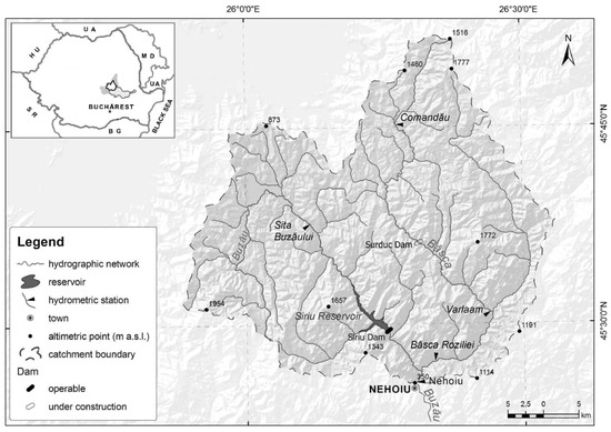
Figure 1
Open AccessArticle
Variation and Transformation of Evapotranspiration at Different Scales in a Desert Steppe
Water 2024, 16(2), 288; https://doi.org/10.3390/w16020288 - 15 Jan 2024
Abstract
►▼
Show Figures
Water resources are severely scarce in desert steppes, and precipitation rarely collects in rivers or is transformed into groundwater. Evapotranspiration (ET) is the primary “export” of precipitation conversion and is the main mechanism for water vapor exchange between the underlying surface and atmosphere.
[...] Read more.
Water resources are severely scarce in desert steppes, and precipitation rarely collects in rivers or is transformed into groundwater. Evapotranspiration (ET) is the primary “export” of precipitation conversion and is the main mechanism for water vapor exchange between the underlying surface and atmosphere. ET changes have certain scale effects. This study focused on the natural grasslands in the Xilamuren Desert Steppe and analyzed and estimated the ET patterns at different scales, including micro-, point-, and surface scales, using observational data from instruments such as a photosynthetic meter, Eddy-covariance system (EC), and large-aperture scintillometer (LAS) from the Ecological Hydrology National Field Science Observation Station in the northern foothills of the Yin Mountains, Inner Mongolia. The spatial scale was extended based on this analysis. The results showed that at the microscale, the diurnal variation in the photosynthetic and transpiration rates of Leymus chinensis followed a bimodal curve. In July and August (high-temperature months), photosynthetic and transpiration rates were almost synchronous. In May and October, when the temperature was moderate, the transpiration rate was delayed compared to the photosynthetic rate at the first peak, and the second peak was significantly smaller than the first peak. At the point-scale, the daily average ET during the growing season was 1.37 mm·d−1 and the total cumulative ET was 251 mm. Transpiration levels exhibited significant seasonal variation in the following order: July > August > June > September > May > October. At the surface-scale, the daily average ET during the growing season was 1.60 mm·d−1 and the total cumulative ET was 294 mm, which was 17% higher than that of the point-scale. The surface-scale ET was estimated using the observed values of the EC and the scale relationship formula and was optimized using different spatial scales of crop coefficients. This well reflected the ET patterns at the surface-scale. Therefore, this study proposes a spatial scale expansion method for a homogeneous underlying surface, verifies its value, and provides methodological support for estimating ET in cases of data scarcity.
Full article
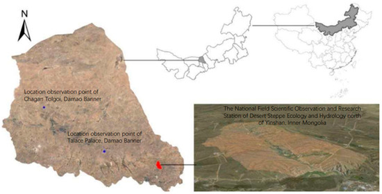
Figure 1
Open AccessArticle
Groundwater Age and Origin and Its Relation with Anthropogenic and Climatic Factors
by
, , , , , and
Water 2024, 16(2), 287; https://doi.org/10.3390/w16020287 - 15 Jan 2024
Abstract
Groundwater plays a major role in addressing the worldwide problem of water scarcity and food security. With a growing population and increasing urbanization, there is a rising demand for groundwater to meet agricultural and domestic water needs. A variety of advanced approaches are
[...] Read more.
Groundwater plays a major role in addressing the worldwide problem of water scarcity and food security. With a growing population and increasing urbanization, there is a rising demand for groundwater to meet agricultural and domestic water needs. A variety of advanced approaches are necessary to sustain groundwater management. This study investigated the age and origin of groundwater, as well as its relationship with anthropogenic and climatic factors. Stable isotopes were used, namely oxygen-18 (18O) and deuterium (2H) for the estimation of groundwater origin and radioactive isotopes of Tritium (3H) for the estimation of its age. The investigation of stable isotopes revealed that the aquifer is predominantly influenced by river water, with a minor contribution from rainwater. Furthermore, the analysis of radioactive isotopes revealed that the groundwater age ranges from 5 to 50 years old in most areas. Older groundwater is predominantly found in urban areas, while younger groundwater is present in agricultural and woodland regions. However, the presence of “old” water in the upper groundwater layers in urban areas is attributed to over-abstraction and limited natural recharge. The primary climatic factor that governs the age and origin of groundwater is rainfall upstream of the study area, which directly contributes to the river flows. The rainfall is high in the east but, due to urbanization, recharge is decreased. Consequently, old and river recharge groundwater is found in this area. These observations underscore the unsustainable and alarming use of groundwater in urban areas.
Full article
(This article belongs to the Special Issue Effect of Climate Change and Anthropogenic Activities on Groundwater Resources)
►▼
Show Figures
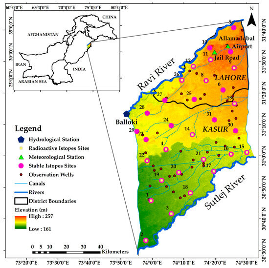
Figure 1
Open AccessArticle
Assessing Recession Constant Sensitivity and Its Interaction with Data Adjustment Parameters in Continuous Hydrological Modeling in Data-Scarce Basins: A Case Study Using the Xinanjiang Model
Water 2024, 16(2), 286; https://doi.org/10.3390/w16020286 - 14 Jan 2024
Abstract
►▼
Show Figures
Data scarcity plays the crucial role in hydrological modeling, causing the uncertainties in hydrological model calibration and parameterization. Therefore, while considering the sensitivity of the parameter optimization, it is essential to determine which parameters have the most significant implications on model performance, especially
[...] Read more.
Data scarcity plays the crucial role in hydrological modeling, causing the uncertainties in hydrological model calibration and parameterization. Therefore, while considering the sensitivity of the parameter optimization, it is essential to determine which parameters have the most significant implications on model performance, especially when there is limited hydro-climatological information. Previous studies have underscored the significance of data adjustment parameter sensitivity and its consequential influence on both Xinanjiang (XAJ) model performance and the determination of the acceptable minimum data length, particularly in data-scarce regions. Nevertheless, it is essential to consider the recession constant sensitivity as it has been identified as the most sensitive parameter on an annual scale while keeping the data adjustment parameters constant during a period of data scarcity. Hence, the objective of this study is to extend the previous research by examining the relationship between recession constant sensitivity and data adjustment parameters in shorter datasets leading to more reliable parameter estimation for data-scarce basins. Five U.S. river basins were analyzed using the 28-year dataset and shorter subsets to highlight the impacts of recession constant sensitivities with different data lengths. This study explores the impact of recession constant sensitivities over the hydrological parameter estimation using two approaches (cg): (i) assessing the relationship between the recession constant (cg) and the data adjustment parameter (Cep), for the 28-year dataset, and (ii) investigating the significant impacts of the sensitivity of cg over Cep in shorter datasets, which can affect the estimation of the acceptable minimum data length in the data-scarce basins. The polynomial regression analysis was applied to compare and evaluate the model results, varying over the recession constant with different data lengths. The findings indicated that the influence of the recession constant over the data adjustment parameters in the 28-year dataset is limited in the annual scale. However, there is a significant impact of recession constant sensitivity over the model performance while calibrating the model with subsets, particularly in the worst-case scenario. This study underscores the importance of the recession constant sensitivity for reliable continuous hydrological model predictions, especially in data-scarce areas.
Full article
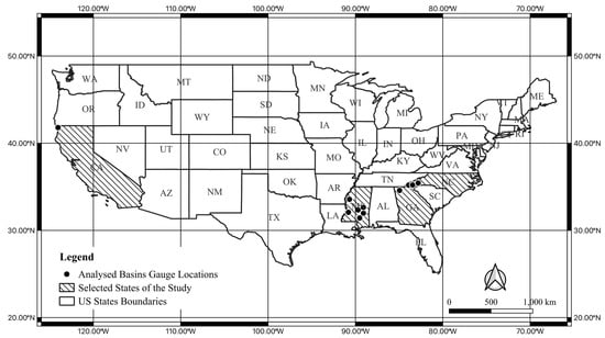
Figure 1
Open AccessReview
A Scientometric Review for Uncertainties in Integrated Simulation–Optimization Modeling System
Water 2024, 16(2), 285; https://doi.org/10.3390/w16020285 - 14 Jan 2024
Abstract
Water resources management is a challenging task caused by huge uncertainties and complexities in hydrological processes and human activities. Over the last three decades, various scholars have carried out the study on hydrological simulation under complex conditions and quantitatively characterized the associated uncertainties
[...] Read more.
Water resources management is a challenging task caused by huge uncertainties and complexities in hydrological processes and human activities. Over the last three decades, various scholars have carried out the study on hydrological simulation under complex conditions and quantitatively characterized the associated uncertainties for water resources systems. To keep abreast of the development of the collective knowledge in this field, a scientometric review and metasynthesis of the existing uncertainty analysis research for supporting hydrological modeling and water resources management has been conducted. A total of 2020 publications from 1991 to 2018 were acquired from the Web of Science. The scientific structure, cooperation, and frontiers of the related domain were explored using the science mapping software CiteSpace V5.4.R3. Through co–citation, collaboration, and co–occurrence network study, the results present the leading contributors among all countries and hotspots in the research domain. In addition, synthetical uncertainty management for hydrological models and water resource systems under climatic and land use change will continue to be focused on. This study comprehensively evaluates various aspects of uncertainty analysis in hydrologic simulation–optimization systems, showcasing advanced data analysis and artificial intelligence technologies. It focuses on current research frontiers, aiding decision–makers in better understanding and managing the complexity and uncertainties of water resource systems, thereby enhancing the sustainability and efficiency of responses to environmental changes.
Full article
(This article belongs to the Special Issue Reservoir Control Operation and Water Resources Management)
►▼
Show Figures
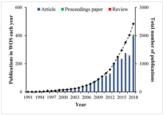
Figure 1
Open AccessArticle
A New Open Channel Flow Correction Method Based on Different Boundary Combinations in Hydraulic Modeling
by
, , , , , , and
Water 2024, 16(2), 284; https://doi.org/10.3390/w16020284 - 13 Jan 2024
Abstract
In open-channel water transfer projects, hydrodynamic modeling has been one of the tools commonly used by the scheduling staff to perceive the changes in the water condition of the channel. The reliability of the flow monitoring data has not been guaranteed due to
[...] Read more.
In open-channel water transfer projects, hydrodynamic modeling has been one of the tools commonly used by the scheduling staff to perceive the changes in the water condition of the channel. The reliability of the flow monitoring data has not been guaranteed due to restrictions in the flow monitoring method. Flow monitoring errors directly reduce the accuracy of hydrodynamic modeling calculations, making it impossible to accurately grasp the real-time changes in the internal water conditions of the channel. In this paper, by utilizing the characteristics of the hydrodynamic model itself, which can be solved discretely with multiple boundary conditions, the method of correcting the boundary anomaly data is proposed by changing the combination of hydrodynamic boundaries. This solves the problem of the inaccuracy of hydrodynamic model calculations due to errors in the monitoring data and improves the accuracy of the hydrodynamic model calculations. In the actual operation process, it is found that the method proposed in this paper solves the problem of hydrodynamic model misalignment caused by flow observation errors by correcting the flow during the flow adjustment period, which greatly improves the calculation accuracy of the hydrodynamic model. Secondly, for a stable flow period, the method proposed in this paper can quickly capture and correct the local monitoring of abnormal data and improve the overall hydrodynamic simulation accuracy.
Full article
(This article belongs to the Section Hydrology)
►▼
Show Figures
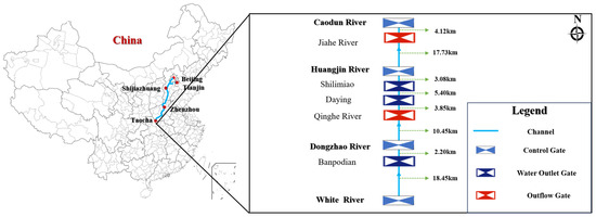
Figure 1
Open AccessArticle
Recovery of a Population of Slimy Sculpin (Uranidea cognata) after an Autumn Fish Kill in the Headwaters of a Minnesota Trout Stream
Water 2024, 16(2), 283; https://doi.org/10.3390/w16020283 - 13 Jan 2024
Abstract
Toxic runoff from heavy rains on 26 September 2019 caused a complete fish kill on the 2 km long headwater reach of Garvin Brook, Winona County, Minnesota, USA. This project examined the recovery of the slimy sculpin (Uranidea cognata) population within
[...] Read more.
Toxic runoff from heavy rains on 26 September 2019 caused a complete fish kill on the 2 km long headwater reach of Garvin Brook, Winona County, Minnesota, USA. This project examined the recovery of the slimy sculpin (Uranidea cognata) population within the lower 900 m of the kill zone, comparing relative abundance estimates and size structures between the kill zone and a downstream, unimpacted reference section. Electrofishing surveys were conducted at 24 sites (12 within both kill and reference zones) at 6, 11, 18, 28, and 42 months post-kill to assess relative abundance (catch-per-effort (CPE), fish/min) and population age structures (based on total length). At six months post-kill, sculpin were present throughout the kill zone. However, adult CPE declined significantly with upstream distance, which was suggestive of the ongoing immigration of adult sculpin from downstream. Age structures were similar in kill and reference zones with all size/age groups present in both zones after six months, while CPE was twice as high in the reference (6.3 fish/min) versus the kill zone (3.0 fish/min). After 11 months, CPE did not differ between zones (14 fish/min) and remained that way for the remainder of the study. However, age structures differed dramatically between zones at both 11 and 18 months post-kill; adult sculpin were significantly more abundant in the reference zone, whereas juvenile fish dominated the kill zone. By 28 months post-kill, both sculpin abundance and age structure within the kill zone had fully recovered from the kill. Sculpin recovery was accomplished mostly through enhanced reproduction within the kill zone following initial post-kill movements of both adult and juvenile fish into the kill zone from downstream. Low predation on juvenile sculpin due to a reduced abundance of trout and adult sculpin post-kill likely allowed more rapid recovery of the sculpin population within the kill zone.
Full article
(This article belongs to the Special Issue Aquatic Ecosystem: Problems and Benefits)
►▼
Show Figures
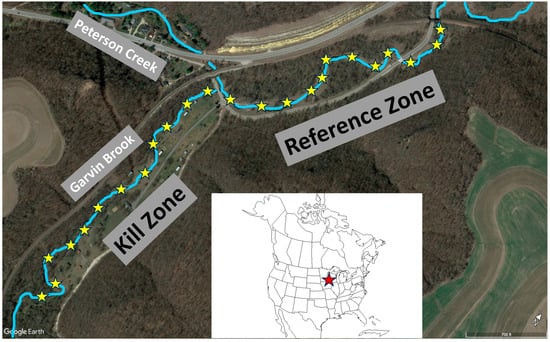
Figure 1
Open AccessArticle
Use of Hydroacoustic Methods to Assess Ecological Status Based on Fish: A Case Study of Lake Dejguny (Poland)
Water 2024, 16(2), 282; https://doi.org/10.3390/w16020282 - 13 Jan 2024
Abstract
The idea of the article was to verify the thesis that acoustic studies of ichthyofauna in lakes provide sufficient information to determine the necessity (or lack thereof) of carrying out a full procedure for assessing the ecological status based on fish. The manuscript
[...] Read more.
The idea of the article was to verify the thesis that acoustic studies of ichthyofauna in lakes provide sufficient information to determine the necessity (or lack thereof) of carrying out a full procedure for assessing the ecological status based on fish. The manuscript compares acoustic data collected in 2008 and 2021 in Lake Dejguny (Poland) as a result of acquisition carried out with the same EY-500 echosounder, on the same routes (transects), and the echogram analyses were carried out using software dedicated to this echosounder. Target strength (TS) distribution was determined in the lake and in individual water layers with a thickness of 2 m, as well as, using the mapping method, changes in the distribution of fish in selected water layers. Large changes in TS distribution in the vertical profile were demonstrated between both years of the study, as well as a clear reduction in the space available for fish in waters below 24 m in 2021, which was associated with a reduction in the concentration of dissolved oxygen below this depth to a value lower than 2.5 mg L−1. It was suggested that it could be possible to develop a simple index enabling the assessment of changes in fish structure, based, similarly to the Large Fish Index, on the ratio of the number of large fish to small fish. The obtained results confirmed that the proposed methods of acoustic data analysis can be the basis for the decision on the necessity (or lack thereof) of conducting an assessment using the Polish national LFI-EN method based on the results of one-off fishing with Nordic multimesh gillnets.
Full article
(This article belongs to the Special Issue Aquatic Ecosystems: Biodiversity and Conservation)
►▼
Show Figures
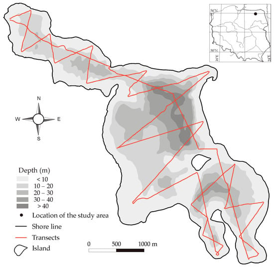
Figure 1
Open AccessArticle
Investigating Flood Characteristics and Mitigation Measures in Plain-Type River-Connected Lakes: A Case Study of Poyang Lake
Water 2024, 16(2), 281; https://doi.org/10.3390/w16020281 - 12 Jan 2024
Abstract
The flow of plain-type river-connected lakes is affected by both upstream and downstream rivers, and the hydrological conditions are very complex. Poyang Lake, situated in Jiangxi Province, is the largest river-connected lake in the Yangtze River Basin. Its unique geographical features and complex
[...] Read more.
The flow of plain-type river-connected lakes is affected by both upstream and downstream rivers, and the hydrological conditions are very complex. Poyang Lake, situated in Jiangxi Province, is the largest river-connected lake in the Yangtze River Basin. Its unique geographical features and complex hydrological conditions have made it a heavy disaster area and a frequent area of floods since ancient times. As typical mitigation measures of Poyang Lake, semi-restoration polder areas and flood storage and detention areas play a crucial role in the flood control of Poyang Lake. Taking Poyang Lake as an example, this article studies the flood characteristics of Poyang Lake based on the measured hydrological data. Furthermore, by using the weir (gate) outflow formula to construct the hydraulic model of semi-restoration polder areas and DHI MIKE to construct the hydrodynamic model of Kangshan flood storage and detention area, the flood diversion capacity of the two, and the flood diversion effect under the super-historical flood in 2020 are analyzed. The results show that compared with the non-use of mitigation measures, the maximum cumulative reduction in Xingzi water level can be reduced by 0.68 m and 0.48 m when semi-restoration polder areas and Kangshan flood storage and detention areas are used alone. Finally, the article puts forward some thoughts and suggestions on the flood control of Poyang Lake. The research results can offer some reference to the flood risk management of plain-type river-connected lakes.
Full article
(This article belongs to the Special Issue Flood Risk Identification and Management)
►▼
Show Figures
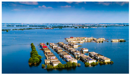
Figure 1
Open AccessReview
An Overview of the Progress made in Research on Odor Removal in Water Treatment Plants
Water 2024, 16(2), 280; https://doi.org/10.3390/w16020280 - 12 Jan 2024
Abstract
Odor is one of the most intuitive indicators for assessing drinking water quality in waterworks. Removing odors is of great importance to improve the quality of tap water, ensure people’s health, and address public perception. The effective identification of odors in drinking water
[...] Read more.
Odor is one of the most intuitive indicators for assessing drinking water quality in waterworks. Removing odors is of great importance to improve the quality of tap water, ensure people’s health, and address public perception. The effective identification of odors in drinking water and the exploration of the source of the odor are the prerequisites for eliminating odors. Therefore, this article first discusses the sources and types of odors that are typical in current drinking water, focuses on reviewing the research progress of odor removal technologies in water treatment plants, including adsorption technology, chemical oxidation technology, biodegradation technology and combined technology, and explains the advantages, disadvantages, principles, research progress, practical application scenarios, considerations and application prospects of each odor-removal technology. It is expected to provide a reference for controlling odor pollution in drinking water.
Full article
(This article belongs to the Special Issue Low-Carbon Water Treatment Technology)
►▼
Show Figures
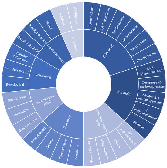
Figure 1

Journal Menu
► ▼ Journal Menu-
- Water Home
- Aims & Scope
- Editorial Board
- Reviewer Board
- Topical Advisory Panel
- Instructions for Authors
- Special Issues
- Topics
- Sections & Collections
- Article Processing Charge
- Indexing & Archiving
- Editor’s Choice Articles
- Most Cited & Viewed
- Journal Statistics
- Journal History
- Journal Awards
- Society Collaborations
- Conferences
- Editorial Office
Journal Browser
► ▼ Journal BrowserHighly Accessed Articles
Latest Books
E-Mail Alert
News
Topics
Topic in
Catalysts, Materials, Nanomaterials, Water, Applied Sciences
Emerging Materials in Water and Waste Remediation Processes
Topic Editors: Juan García Rodríguez, Silvia Álvarez-TorrellasDeadline: 31 January 2024
Topic in
Energies, Hydrology, JMSE, Remote Sensing, Water
Application of Smart Technologies in Water Resources Management
Topic Editors: Elias Dimitriou, Joaquim SousaDeadline: 29 February 2024
Topic in
Atmosphere, Hydrology, Remote Sensing, Sustainability, Water
Hydrology and Water Resources Management
Topic Editors: Genxu Wang, Hongwei Lu, Lei Wang, Bahman NaserDeadline: 30 March 2024
Topic in
GeoHazards, Geosciences, Land, Remote Sensing, Water
Landslide Detection and Monitoring Using Multisource Remote Sensing Data
Topic Editors: Haijun Qiu, Wen Nie, Afshin Asadi, Pooya SaffariDeadline: 31 March 2024

Conferences
Special Issues
Special Issue in
Water
Nature-Based Solutions for Rainwater Management in the Urban Environment
Guest Editors: Luca Giovanni Lanza, Arianna CauteruccioDeadline: 20 January 2024
Special Issue in
Water
Flood Risk and Response Management
Guest Editors: Dimitrios A. Emmanouloudis, Elissavet Feloni, Fotis Maris, Panagiotis NastosDeadline: 25 January 2024
Special Issue in
Water
SWAT Modeling - New Approaches and Perspective
Guest Editors: Manoj K. Jha, Philip W. Gassman, Raghavan Srinivasan, Ryan BaileyDeadline: 10 February 2024
Special Issue in
Water
Effects of Microplastics Pollution in the Aquatic Environment
Guest Editor: Judith S. WeisDeadline: 20 February 2024
Topical Collections
Topical Collection in
Water
Water Policy Collection
Collection Editors: Meri Raggi, Davide Viaggi, Giacomo Zanni


